Crossing Switzerland on Foot
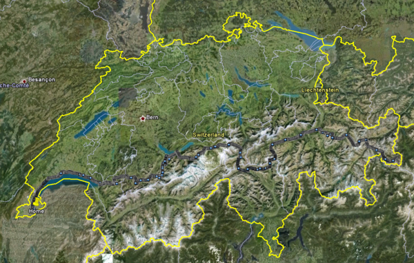
In early 2009, I set out to plan a hike starting at my house in Geneva, the western most part of Switzerland, and ending in Santa Maria - Mustair, the eastern most part of the country.
I bought all 58 1:50,000 official hiking maps issued by the Office Fédéral de Topographie and spent hours pouring over these beautiful maps as well as consulting the interactive map on www.wanderland.ch. I planned a route that avoided, as much as possible, densely populated areas and traversed many mountain passes of the Swiss Alps (Vaud and Bernese Alps, then into Uri, Ticino and Engadine).
I imposed a few rules. First, I only used public transportation to get to and back from my stop points. For example, I would take the train and bus back from Andermatt to my my house in Geneva and then when I wanted to resume the hike, I would take the bus and train back to Andermatt.
Second, I never reserved a room for sleeping. This allowed me to change routes when I felt it necessary and resulted in some pleasant and some less pleasant lodging experiences. However, even CHF 40 guest houses in Switzerland are clean and safe. I avoided sleeping in mountain huts for comfort and logistical reasons. They are charming, but having spent a good number of nights bunked next to stinking and snoring mountaineers at high altitude (which does not help with sleep) this was not an experience I wanted to replicate for this trip.
Finally, I did not want to use any guides. While I was slightly anxious about crossing some of the more remote passes alone and relying on my own navigation, this made the trip hugely satisfying. I learned a lot. I had planned thoroughly, I had very good maps and I had bought a GPS and taught myself how to use it (I also used the GPS to audit the trip and this allowed me to generate all the stats below).
Here are some stats: I had calculated that the trip would take 22 to 28 days (it was 24 in the end). I did not have the time to do this in one go and I wanted to hike when the weather was pleasant. So I ended up doing 4 one-day hikes, 3 three-day hikes, 1 four-day hike and 1 six-day hike.
I walked a total of 647 km (402 miles). The longest one-day walk was 41.6 km (25.8 miles). The total elevation gain for the trip was 29,718 m (97,500 feet) - that is 3.4 times Mt. Everest from sea level in case you are wondering. The single highest one-day elevation gain was 2,260 m (7,415 feet).
This was a phenomenal experience. Switzerland is a stunning country with uncorrectable high mountains - some of the scenery has not changed for thousands of years. If you want some ideas for a trail or two check out the route below or drop me a line.
Swiss Crossing Itinerary
|
Day |
Date |
Departure Place |
Arrival Place |
Distance |
Total Distance |
Elevation Gain |
Total Elevation Gain |
|
1 |
Friday, June12, 2009 |
Geneva |
Rolle |
39.6 |
39.6 |
374 |
374 |
|
2 |
Friday, June19, 2009 |
Rolle |
Morges |
18.8 |
58.4 |
360 |
734 |
|
3 |
Monday, June22, 2009 |
Morges |
Montreux |
41.6 |
100.0 |
636 |
1,370 |
|
4 |
Thursday, June25, 2009 |
Montreux |
La Lécherette |
28.2 |
128.2 |
2,260 |
3,630 |
|
5 |
Sunday, June28, 2009 |
Gstaad |
Lenk |
23.4 |
151.6 |
1,221 |
4,851 |
|
6 |
Monday ,June29, 2009 |
Lenk |
Adelboden |
15.2 |
166.8 |
1,176 |
6,027 |
|
7 |
Tuesday ,June30, 2009 |
La Lécherette |
Château d'Oex |
15.6 |
182.4 |
585 |
6,612 |
|
8 |
Monday, July27, 2009 |
Adelboden |
Kandersteg |
21.6 |
204.0 |
1,359 |
7,971 |
|
9 |
Tuesday, July28, 2009 |
Kandersteg |
Kiental |
22.5 |
226.5 |
1,259 |
9,230 |
|
10 |
Wednesday, July29, 2009 |
Kiental |
Interlaken |
30.1 |
256.6 |
1,427 |
10,657 |
|
11 |
Friday, August07, 2009 |
Château d'Oex |
Gstaad |
15.3 |
271.9 |
540 |
11,197 |
|
12 |
Tuesday, August18, 2009 |
Interlaken |
Grindelwald |
22.4 |
294.3 |
960 |
12,157 |
|
13 |
Wednesday, August19 ,2009 |
Grindelwald |
Gadmen |
38.5 |
332.8 |
2,096 |
14,253 |
|
14 |
Thursday, August20, 2009 |
Gadmen |
Andermatt |
39.6 |
372.4 |
2,230 |
16,483 |
|
15 |
Tuesday, June22, 2010 |
Andermatt |
Lago Ritum |
28.8 |
401.2 |
1,803 |
18,286 |
|
16 |
Wednesday, June23, 2010 |
Lago Ritum |
Campo |
27.1 |
428.3 |
1,232 |
19,518 |
|
17 |
Thursday, June24, 2010 |
Campo |
Val |
27.4 |
455.7 |
1,680 |
21,198 |
|
18 |
Saturday, June26, 2010 |
St. Maria |
Bufalora |
22.4 |
478.1 |
1,292 |
22,490 |
|
19 |
Sunday, June27, 2010 |
Bufalora |
Susch |
26.3 |
504.4 |
704 |
23,194 |
|
20 |
Monday, June28, 2010 |
Susch |
Davos |
33.7 |
538.1 |
1,487 |
24,681 |
|
21 |
Wednesday, October06, 2010 |
Val |
Ilanz |
26.3 |
564.4 |
566 |
25,247 |
|
22 |
Thursday, October07, 2010 |
Ilanz |
Chur |
37.7 |
602.1 |
1,095 |
26,342 |
|
23 |
Friday, October08, 2010 |
Chur |
Arosa |
27.9 |
630.0 |
2,247 |
28,589 |
|
24 |
Saturday, October09, 2010 |
Arosa |
Davos |
17.0 |
647.0 |
1,129 |
29,718 |